



Mark Boomer <mark.boomer@9habu.com>
Feb 26, 2026, 5:57 PM
to mcc
Dear Sir or Madam,
I am writing to request access to any historical Cospas‑Sarsat Mission Control Centre (MCC) records held by the Toulouse MCC relating to a distress alert received on 3 December 1995 in the central Mediterranean region.
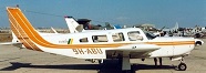
The incident concerns the disappearance of a Piper Lance aircraft, registration 9H‑ABU, which was flying from Djerba, Tunisia to Malta on 3 December 1995 with six men on board: Carmelo Bartolo, Matthew Aquilina, Philip Farrugia, Desmond Boomer, Michael Williams, and Tadeusz Gorny.
During the international search effort, a distress signal was reported as having been received by satellite and relayed “via Toulouse MCC”, described at the time as VHF‑2121‑5, and associated with a location east of Tripoli, Libya, possibly near a disused airfield.
I respectfully request any of the following records, if they exist in your archives:
- MCC alert messages, beacon detections, or satellite‑pass data relating to this signal on or around 3 December 1995.
- Any MCC‑to‑RCC or MCC‑to‑MCC communications referencing this alert, including exchanges with NOAA, USCG, Malta RCC, Tunisia, or Libya
- Any internal MCC notes, analyses, or summaries concerning the signal identified as VHF‑2121‑5 or any unidentified distress alert in the central Mediterranean on that date.
- Any records specifically referencing the aircraft 9H‑ABU or the associated search effort.
I am happy to receive all material in digital format.
This request is made for the purpose of reconstructing the events surrounding the loss of the aircraft and the six men on board, one of whom was my brother, Desmond Boomer.
If there is a formal process, fee, or specific department to contact for historical Cospas‑Sarsat data, I would be grateful for your guidance.
Thank you for your assistance.
Name: Mark Boomer
Email: mark.boomer@9habu.com
Poudevigne David (DAM) <David.Poudevigne.external@cnes.fr>
Tue, Mar 3, 2:30 PM
to me
Dear Sir,
It took me some time to gather some elements to provide you with the most accurate answer. First of all, I am sincerely sorry for the loss of your brother. Unfortunately, it may be difficult for me to help you. Data regarding distress operations is not open data, and even if I do understand your situation, I have to respect my national regulations on this matter. However, if you can get an official support from either your maritime authority (MCA), your aeronautical authority or any diplomatic support, it would help. Nevertheless, I doubt that we are in possession of exhaustive archives from this particular event. I guarantee you that I will do my best to check what I can collect, and what I have the right to give you. I want to make it very clear, please do not expect any file as detailed as we are working with now.
I will contact the French national aviation authority, the Cospas-Sarsat Programme Secretariat, and the Space Agency archives department. I will come back to you as soon as possible. On your side, please consider getting a letter or any kind of official support.
My best regards,
David Poudevigne
Chef FMCC / Head of FMCC
FMCC COSPAS-SARSAT
Centre Spatial Toulouse - Bpi903
18, Avenue E.Belin
31401 TOULOUSE Cedex 9, FRANCE
Tel : +33 561 28 28 18
Mark Boomer <mark.boomer@9habu.com>
Mar 4, 2026, 10:30 AM
to Poudevigne
David
Thank you.
I have contacted Irish Foreign Affairs in Dublin to request their support for this request.
I will let you know when I receive their response.
Mark Boomer
Poudevigne David (DAM) <David.Poudevigne.external@cnes.fr>
Mar 11, 2026, 8:03 AM
to me
Dear Sir,
I have checked with out technical teams here, antennas and processing systems, and we do not have any archives on this case. I have also contacted the International Organisation, to ask for any elements, and they do not keep archives on these incidents.
However, if you find any Cospas-Sarsat related documents, such as localization messages, detection messages, or if you have any questions related to how the system work, I can help you.
I am very sorry for this answer.
My best regards,
David Poudevigne
Chef FMCC / Head of FMCC
Mark Boomer <mark.boomer@9habu.com>
Attachments
Mar 11, 2026, 12:05 PM
to Poudevigne
David
Thank you for taking the time to look into this.I appreciate that it was very unlikely that any information relating to the search would still be retained after 30 years.
The only information I have is the attached image, which is very poor quality.
Details about this image can be found on the following web pages
Letter from Cecilia Pellegrini to Maltese PM Fenech Adami re: PM visit to Libya
Thank you for your attention to this matter.
Mark Boomer
Poudevigne David (DAM) <David.Poudevigne.external@cnes.fr>
Mar 11, 2026, 1:14 PM
to me
Dear Mark,
I can confirm the photograph looks like a real Cospas-Sarsat message sent to Search And Rescue Services by Toulouse. I don’t know which SAR center received it. It is indeed written “FMCC Toulouse”, which is the name of the center that would have sent this message.
Checking the coordinates gives a position close to Tripoli Airport (I can read 32 52.3N // 13 14.18E on the first line, and… the same on the second one). At this time, however, the beacon code was not sent to the satellite, so it is impossible to confirm which beacon is involved in the incident.
One thing I cannot explain is that the two positions seem to be the same, and they should not be. Location A and Location B are the 2 locations calculated via Doppler Effect by the Satellite when passing over the signal source. They are expected to be like 1 000 km away from one to the other. That is why the system used to wait for a second satellite pass over the distress, so at least one of the two new locations matches with the first ones, making it clear which position is correct.
Regarding Probability (there, it is 50/50), this is a bit useless, It depends on the rotation of the Earth. It has nothing to do with the reliability of the signal.
I can read in your letter retranscription that the next satellite passes could not get any signal, making it very certain that the beacon was turned off (or was destroyed). This is indeed plausible, as satellites footprints should pass over a beacon to detect it, and the signal should last long enough for the satellites to receive at least 3 beacon bursts to allow a calculation. Today requirements are 1 burst each 50 seconds. I don’t know if it was the case in 1995. I will check.
I will ask one of my teammate who has been working here in Toulouse for a long time why the Doppler positions are the same and if beacons bursts were already programmed to happen each 50 seconds.
I will come back to you soon.
My best regards,
David
Poudevigne David (DAM) <David.Poudevigne.external@cnes.fr>
Mar 12, 2026, 10:00 AM
to me
Dear Mark,
So, I showed your message to my teammate. No good news. What we can confirm is that :
This message was sent to Libya RCC – 100% sure (we can recognize their aeronautical address). At this time, Libya was linked to France. They are now linked with Italy (via ITMCC, an agency belonging to the Gardia Costiera).
About the localization, as I told you, the fact the 2 Dopplers make sense in one particular case. This situation occurs only when the satellite flies straight over the beacon. In this particular case, it means that the error of location can high, up to 500 to 1000km. To my understanding, I can tell you that the location should not be considered as reliable. The event could have occurred at sea, or deeper South.
I hope this helps. If you need more accurate or technical details, do not hesitate to ask.
My best regards,
David
Mark Boomer <mark.boomer@9habu.com>
Mar 12, 2026, 5:46 PM
to Poudevigne
David
Thank you again for your analysis of the information.
Would you mind reviewing this information from inquiry : Report published by the Tunisian Ministry Of Transport
In the section labelled, "Interception Of A Distress Signal By A Boat Sailing Towards Sfax", there is a paragraph which says,
"After verification from the world centre for location distress signals by satellite at Toulouse (COSPAS/SARSAT) it is proven that during the day of 3.12.95 Tunisian territory was not covered by satellite during the hours of 3h 30mn and 4h 52mn."
Does this explanation, that there was no satellite cover, sound accurate when considered against your assessment that the only way to make sense of the signal report is that the satellite was "exactly" overhead.
Mark
Poudevigne David (DAM) <David.Poudevigne.external@cnes.fr>
Mar 13, 2026, 1:59 PM
to me
Hello Mark,
It is difficult for me to ta confirm or not the satellites pass at this time. I will assume that the sentence “Tunisian territory was not covered by satellite during the hours of 3h 30mn and 4h 52mn” is 100% sure.
At this time, there were a few number of Cospas-Sarsat low earth orbit satellite, meaning that the globe not 100% covered every time. When a beacon was activated, it should wait for a satellite to fly over it (the beacon has to be inside the footprint of visibility on earth of the satellite). At this latitude, waiting about 80 minutes between two coverages is decent, and stands within the Cospas-Sarsat technical references. So, this sentence can be considered as 100% correct, at a technical level.
About the fact that the satellite was on top of the beacon, my sentence is not 100% accurate. What I meant is that, due to the fact the the Two doppler positions seam to be the same, it means that the satellite track fly right above the beacon. It does not mean that at 0337, the satellite was on top of the beacon. It means that during its flight at this position, when the beacon was transmitting (a burst up every 50 seconds), every burst that arrived to the satellite made a line , and on this line, there was the beacon position. This position is difficult to handle, because the satellite is blind in that situation. To be able to calculate a position, the satellite needed to fly a bit on the East or on th West of the line drawn with the beacon burst positions.
HOWEVER, reading the webpage, I find something interesting. There is indeed a vessel that reported receiving a 121.5 distress signal
“The boat "Supply Asperay" announces having received a distress call on 3/12/95 at 04h 44mn originating from a location at 6 nautical miles north east of Miskar 34 degrees 22°N 11 degrees 52°E on the emergency frequency 121.5 Mhz”
121.5 distress signal is used for radiolocation, meaning that when you receive such a signal, you just go straight heading to this position and you find the distress. If the plane is at sea level (altitude 0m), the signal is not going far from the position. It means that this vessel, “Supply Asperay”, was close to the real position. This position also matches the range of uncertainty coming from the Toulouse Cospas-Sarsat position.
Again, I hope this helps. TO not hesitate to ask for more accurate information.
My best regards,
David
Mark Boomer <mark.boomer@9habu.com>
Mar 13, 2026, 4:38 PM
to Poudevigne
David
Thank you again for that explanation.
An interesting point was raised about that ship in the Board Of Inquiry Report
"5.7 Furthermore the same witness referred to a message from the Tunisian authorities regarding a distress call received from supply ship "Asperay". A similar distress signal is also alleged to have been received by the same authorities from the supply vessel "Gonfulut", It Is to be noted that Colonel Vassallo, in his evidence to the Board stated that he personally checked on these ships with Lloyds Maritime Information Service and was informed that Lloyds had no records about such ships"
Mark Boomer